HOME > News
Last Update 2025.11.11
Caihong Li, Xujiao Zhang, Changbao Guo, Yiqiu Yan, Weimin Yang, Christopher Gomez, Zhihua Yang & Wenkai Chen. 2025. Multi-level slip zone development and composite deformation mechanisms of a fault-related ancient landslide: integration of InSAR, LiDAR, and geophysical exploration in eastern Tibetan Plateau. *Landslides* (2025).https://doi.org/10.1007/s10346-025-02627-3
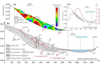
Due to the complex structural deformation of active fault zones and their unique geological and geotechnical conditions, large-scale ancient landslides with frequent deformation and reactivation events are a common occurrence. However, current studies still face challenges in clarifying their deformation patterns. This study investigates the deformation pattern of the Xialazong ancient landslide along the Xianshuihe Fault Zone in the eastern Tibetan Plateau, utilizing a combination of SBAS-InSAR, UAV-based LiDAR, geophysical surveys, and core drilling. The study reveals that the ancient landslide has developed multiple sliding zones, with an average sliding mass thickness of approximately 50 m and a total volume of about 36 × 106 m3. From 2018 to 2022, the cumulative displacement reached −108 mm, with a maximum deformation rate of −19.05 mm/year. Areas of intense deformation are mainly concentrated in the central and front parts of the landslide. Seismic cracking and fault creep in the active tectonic zone have fragmented the rock mass and promoted crack development. Under the combined influence of fault creep and rainfall infiltration, these cracks have expanded into secondary sliding zones. A total of three sliding zones have been identified within the ancient landslide. Deformation of the ancient landslide first appeared at the front edge of the southern slope, then propagated backward, resulting in traction-type deformation. On the northern slope, thrust-type deformation initiated from the central secondary landslide. The Xialazong landslide is currently undergoing continuous deformation, with two episodes of sustained heavy rainfall after August 2020 further accelerating creep deformation in certain sections. The reactivation of large ancient landslides within active tectonic zones typically exhibits a progressive failure primarily driven by tectonic activity, with localized instability triggered by hydrological conditions. The Xialazong ancient landslide displays a complex deformation pattern of “multi-level sliding zones—multi-stage reactivation,” characterized by thrust-type deformation in the middle northern section and traction deformation at the southern front edge due to river erosion, forming stepped terrain. Under triggers such as rainfall, this area is highly susceptible to landslide-dam formation and potential dam-break disaster chains. Therefore, strengthening deformation monitoring of large landslides in active tectonic zones is crucial for providing scientific support for major infrastructure planning and regional geological hazard prevention.